Storms River Mouth Rest Camp Garden Route Tsitsikamma
Garden Route - Eastern Cape - South Africa
The place of much water - Storms River
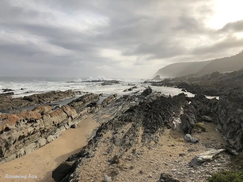
From the N2 on the Garden Route a steep road winds down between high trees and fynbos to the seaside lined with ragged rocks protruding from the sea. This road takes you to the to the Storms River Rest Camp and ultimately closer to the river mouth.
It is a beautiful sunny and relatively still day but some of the trees and shrubs give you an indication of the windy weather conditions this part of South Africa can experience. Even the rocks are at an angle. Is it because of the force of the ocean? I think so.

The previous time we visited Storms River Mouth was during our honeymoon. We spent a few hours exploring and braved the underwater snorkel trail. At that stage I was not sure if my new husband wanted to kindle my adventurous spirit or douse it by drowning me on our honeymoon.
Forty years later, still married and after many great adventures, we decide to camp for four nights on the edge of the ocean in our caravan to see if Storms River still lives up to its name.
Here’s the conundrum. Why go to a campsite on the edge of the ocean, at the start of winter when you know in all likelihood you are going to be bashed by wind and pelted by rain? After all, it is not called Storms River for nothing.
Some worrying thoughts popped into my head. Would our little cave of canvas where we sleep withstand the onslaught of the natural elements? Even worse, would our caravan end up in the ocean? Don’t laugh. If you haven’t experienced the coastal winds along the southern coast of South Africa then you won’t know what I am talking about.

Unsurprisingly and almost unrecognizably the camp had changed and undergone a major revamp. There is even a swimming pool for residents to use. Storms River Mouth Rest Camp in the Tsitsikamma section of the Garden Route National Park belongs to SANParks and has campsites as well as other accommodation. They have log cabins, forest huts, cottages and chalets for any budget.

Forest Huts
We set up camp in the second row of the caravan park to avoid some of the onslaught of the weather, if need be. Not that a few extra metres would make such a difference, in my mind.

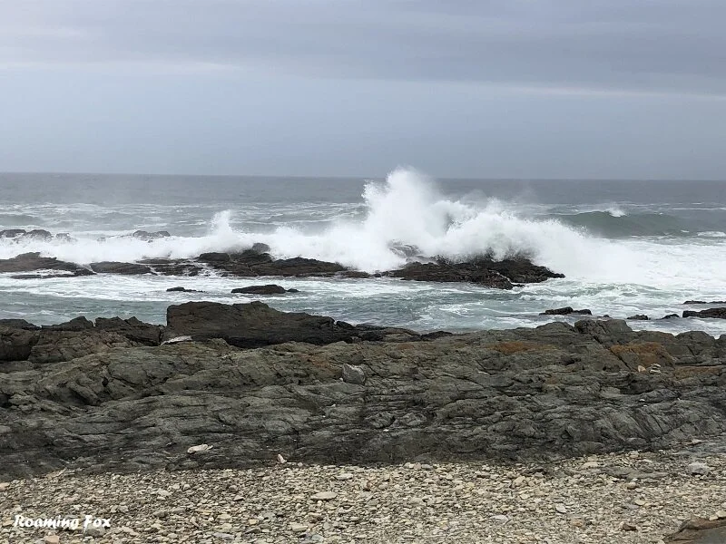
Known as ‘The place of much water’ the area around Storms River is pounded by the Indian Ocean relentlessly. The view across the ocean is breath-taking and you are constantly reminded of the force of the ocean as it booms like a canon. Sometimes you can even feel it reverberating through your body.
You are bound to get enough fresh air as the smell of the sea swirls in with the mist and drifts past. Just as speedily it evaporates.

Weather at Storms River
We were fortunate with the weather for most of the time, but it is everchanging. One of the storms we had the wind howled but was bearable. It rained heavily and hailed though. The gutter at the ablutions broke and crashed onto the ground, thankfully not on anyone’s head.

We had a spectacular show of lightning over the ocean. Churning clouds, dark and thunderous, occasionally lit up with spikes of fluorescent forks that jabbed at the sea. Sorry, no pics.

That night horizontal rain pelted away but we were snug and smug in bed. The following morning we were not so satisfied. With the continuous vibration caused by the wind as well as the heavy rain, the canvas of our sleeping area was saturated. Ultimately a section of our mattress and pillows got soaked.
Thankfully they have large tumble driers at the rest camp and we could dry our pillows and soggy towels. When the sun came out we laid our mattress in the sun to dry. The joys of camping! We’d come up in life though. At least we were above ground and did not have to step into a large puddle like we did at Plettenberg Bay on our honeymoon.

Storms River has a temperate coastal climate. The average annual rainfall is around 1 200mm with the wettest months being May and October. The driest months are during winter in June and July. We were there in May. Go figure.
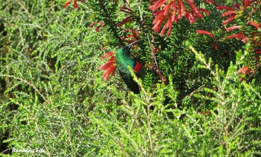
Sunbird - birdwatching is another great activity
Activities at Storms River Rest Camp
Storms River Rest camp has many adventurous activities, although not all of them were operational because of COVID.
All activities are weather dependant as conditions can change rapidly.


The River Mouth Trail
One of the most popular activities is to walk to the bridges that are suspended over Storms River Mouth.
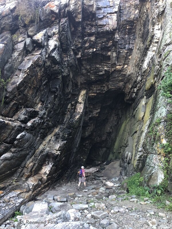
It is an easy 2 kilometre walk through parts of the coastal forest next to the sea. It can be deceptive though because it takes you up and down some steps – steep ones at that. Through the gnarled trees the entire walk will take you about 40 minutes to an hour. For those that are fit and up to it, the trail continues after the bridge and leads to a lookout point on the plateau.


My ‘model’ pulling funny faces.
Snorkel the Inter-tidal Underwater Trail
Another activity is to snorkel the inter-tidal underwater trail. It is situated between rocks close to the start of the Otter and Waterfall Day Trail. As much as I love adventure, I was not going to repeat this activity, especially at the start of winter. Besides, the water looked rather choppy and I had learnt my lesson years ago. What’s that saying - With age comes wisdom…
If you would like to snorkel the trail, choose your time carefully when the tide is right.

Would you snorkel there?
“EXPLORING UNDERWATER
By the time we got there though, the sea was not very cooperative. The Indian Ocean was pounding relentlessly against the rocky shores. The tide was higher than we anticipated and the waves were crashing over the rocks repetitively. The underwater trail was invisible at least to me.
Hubby reassured me it would be fine, but if we wanted to do this, we had to leap in immediately before it was too late. Did I want to leap into the unknown where he’d pointed vaguely at a foamy area? I was convinced my husband was already tired of his new wife, and this was all a ploy to get rid of me and he would surely succeed. Ultimately though it is always difficult for me to ignore a challenge, so in we plunged.
”
Waterfall Day Trail
There are other hikes as well. One of them, Waterfall Day Trail, is the first part of the infamous Otter Trail. Set out early enough as the rock hopping is endless and can be tiring and trying. It is approximately 6km long. Although it says it will take you about 3 hours to complete, the clambering over rocks can take its toll if you are not fit and your legs will feel like jelly.


Why not make a full day of it? Bring some snacks or a picnic lunch and liquid to stay hydrated. If it is warm enough you can even swim at the waterfall. Please note you are not allowed to hike past the waterfall without a valid permit for the Otter Trail which is a multi-day trail.


After much disappointment, we decided to turn back before we reached the waterfall as we set out too late and were concerned we would get back in the dark or worse get stuck at high tide. Although there is an escape path that will take you up to the main gate, it is a mighty steep climb.

Otter Trail
The mother of all hikes at Storms River is the renowned Otter Trail. It is 42km long and takes 5 days and 4 nights to complete. Opened in 1968, it is undoubtedly the oldest and most iconic hiking trail in South Africa.
Overnight accommodation is supplied by the means of wooden huts. Be sure to do your research regarding this trail. It might not be as demanding as some trails but it should not be underestimated. It has technical river crossings because of tide and has some steep climbs and descents.

Hot tip:
The Otter Trail is fully booked well in advance so check availability long before you want to hike.
The Loerie Trail
Another short hike or nature walk, the Loerie Trail, is about 1 kilometre in length and should take you about 1 hour. It starts near the Visitors Centre and has a steep climb up to the plateau which will take you to the Agulhas lookout point.
Blue Duiker Trail
Famed for a view of the Outeniqua Yellowwood, this trail of about 3.7 kilometres takes you through the heart of the forest and ends at the beginning of the Otter Trail after about 2 to 3 hours of walking. Keep your eyes open for blue duiker that frequent the area.
Kayak at the Mouth and gorge of Storms River
Untouched Adventures operate within Storms River Mouth. Ideal for adrenalin junkies, you will be guided by Untouched Adventures and will hike from Sandy Bay on the Mouth Trail for about 30 minutes till you can access the kayaks closer to the gorge. You will then kayak through the gorge and explore the river.


Scuba Diving
Scuba diving is allowed, with the correct certification and equipment, although I have found no extra information about this. It is a protected marine area, so if you enjoy sticking your head underwater it is worth discovering what marine life inhabits these waters.

Restaurant
The Cattle Baron operates the Tsitsikamma Restaurant from a temporary marquee as a wildfire destroyed the main building of the restaurant. The kitchen closed early (about 5.30) and therefore it was not worth having dinner there.
Map of Storms River Mouth Rest Camp area

Eastern side

Western side
Hot tip:
As it is a SANParks Rest Camp you will need a Wild Card or pay an entrance and conservation fee upon entering the park.

Storms River Village is the closest town. If you want to get away from the pounding sea for a few hours, be sure to explore this interesting hamlet.
We met many lovely couples camping at Storms River and had endless chats with them. Two couples well into their 80’s one in a caravan and another in a motorhome, still have an adventurous spirit and I take my hat off to them. Long may they continue in this manner.
Storms River certainly lives up to its name. We endured a storm or two but were fortunate except for a couple of small leaks as the wind pushed the rain into hidden spaces. Nothing we couldn’t handle. If you like storms, this rest camp will not disappoint. Regarding the intensity of the storm, it will depend greatly on the time of year, but that is not a hard and fast rule – a storm can descend upon you at any time.

More hot tips for Storms River Mouth Rest Camp
All weather jacket. As the weather can change at the drop of a hat, take windbreakers or rain jackets because mist can roll in and cool down the air rapidly. Equally, rain can descend in a matter of moments.
Sunscreen and lip balm. Being right next to the see, you can be blasted at any time by wind, sun or rain. Your skin will suffer if you do not take the necessary precautions to protect it.
Footwear for walking. If you intend walking, even if only a short hike, wear suitable walking shoes. The area can be quite damp and slippery in the forest and on the rocks.
Sun hat or warm beanie. A great idea to wear a sun hat or peak – BUT – hold on to it or make sure it is secure on your head before the wind blows it into the sea. A beanie is also useful if the weather turns cold.
Cash. Having some cash is always handy to spend at the small shop which mainly stocks sweets, chocolates and a few curio knickknacks. There is no ATM and I am not sure if there is a credit card machine to pay at the shop or restaurant.
Stocking up when self-catering. The best and closest places to buy groceries is probably Plettenberg Bay or Jeffreys Bay.
No fuel available in the rest camp. The nearest fuel is available next to the N2 at Total Petroport Tsitsikamma, about 20 kilometres away heading east.
Baboons can be a nuisance. Secure your food in a safe place where baboons cannot get to it. In other words, lock it away in your vehicle or in an equally secure place. Some campers had gone out for the day and after returning from one of our walks we discovered their campsite had been ransacked by the baboons who were still enjoying the spoils.
We tried to chase them away as best we could. Unfortunately for the couple, there was nothing left of their food. Baboons have been known to enter the chalets, cottages and log cabins as well, even when you are sitting inside.

Should you visit and explore Storms River Mouth Rest Camp? A resounding yes!

Where is Storms River Mouth?
Map
Pin for later on Pinterest

Pinterest Pin
Save for later

Pinterest Pin
Save for later
Find me on Social Media


About the Author
ALMA VAN AS | ROAMING FOX
Alma is a South African travel blogger and writer. She hopes to inspire you with facts and fables about her adventures, road trips and international travel.
Due to the Covid-19 pandemic there may be some activities that are not available so please check ahead of time to avoid disappointment.
Booking Accommodation
If this article inspires you to travel it would be greatly appreciated if you book your accommodation via the links on this page. Alternatively take a look at my shop page. When you book it will earn us a small commission at no extra cost to you. This will also assist in keeping the Roaming Fox website running.
As always, I appreciate your support. Thanks! – Alma aka Roaming Fox.
The Best Way to see a country? Take a road trip! Have you ever had that feeling when you hit the open road on your road trip? Freedom. Anticipation. Exhilaration.